This is a proposal to use Interstate 5 between Northeast Northgate Way and the Spokane Street Viaduct as the “second downtown tunnel” planned for Seattle in the Sound Transit 3 project (ST3). Between these two points, the entire highway would be converted into a transit corridor. This would require a feat of political courage and interagency cooperation, but would provide the exceptional public transit network that ST3 promised, while eliminating costly and disruptive portions of the project.
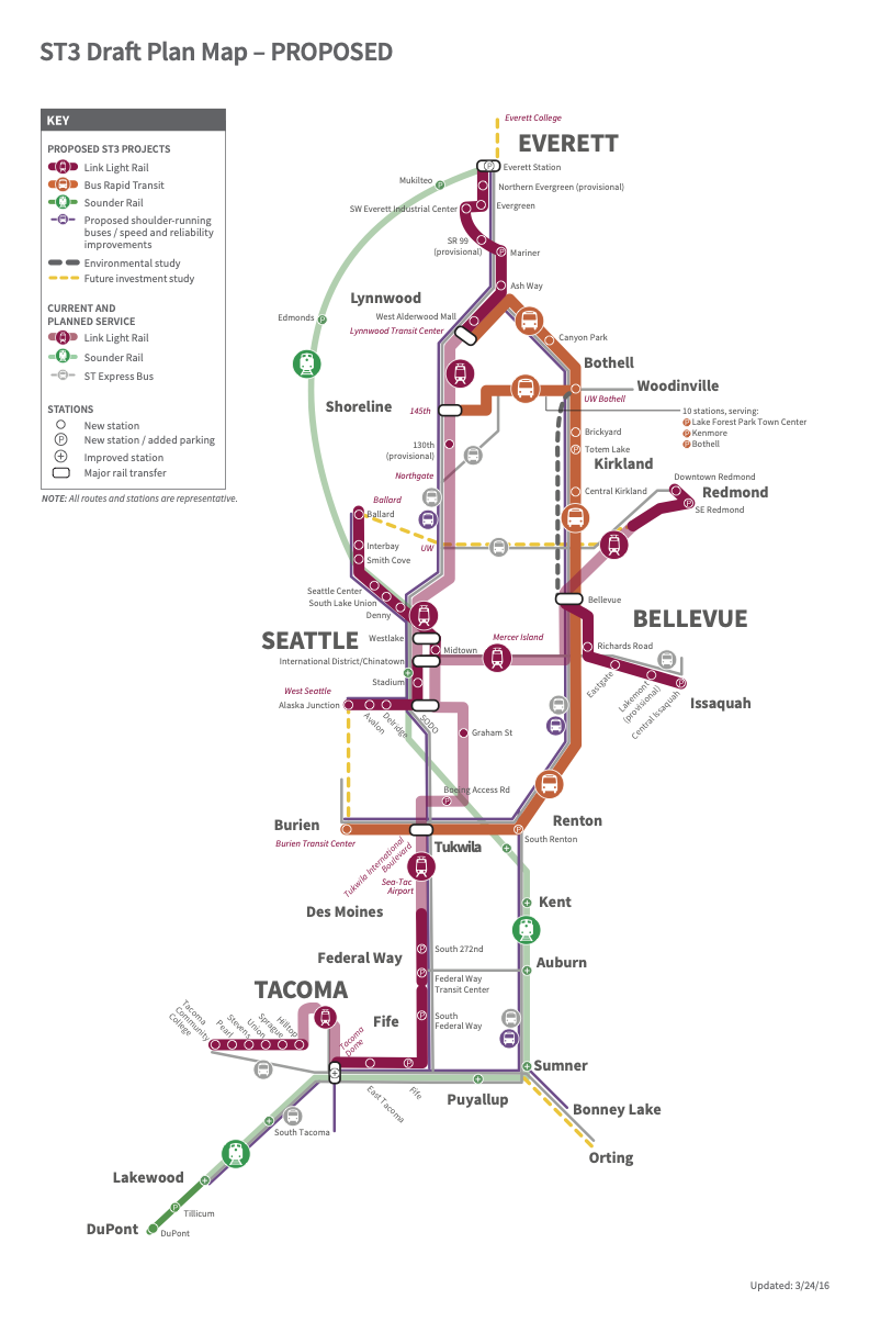
Original ST3 proposal with transfers between tunnels at Westlake Station and International District/Chinatown Station.
The existing plans for a second downtown tunnel have generated discontent over their construction impact and costs. The initial ST3 plan split a previously-envisioned light rail “spine” between Tacoma and Everett, with the second tunnel constituting part of a route between Tacoma and Ballard, and the original downtown Seattle transit tunnel serving a West Seattle to Everett route. This entailed creating transfer points between tunnels at International District/Chinatown Station and Westlake Station. Due to concerns about construction impact, the current ST3 preferred alternative scuttles the former, creating a suboptimal experience—two transfers or backtracking through downtown—for some trips passing through Seattle, such as going from Redmond to the airport. Furthermore, concerns about costs have opened discussions of scrapping a second tunnel altogether.
The current ST3 preferred alternative has the second tunnel avoiding International District/Chinatown Station. Note the indirect transfer situation from the westbound 2 Line (in faded blue) to the southbound preferred Ballard Link Extension, as there is no intersection until Westlake.
Recent 2 Line connection work and emergency repairs in the existing downtown transit tunnel have demonstrated that a second tunnel is essential, even before more rail service runs through Downtown Seattle. In spite of Sound Transit’s various attempts at substitute service, any amount of disruption to the tunnel has yielded transit that has ranged from severely impaired to nearly useless. Even if capacity projections indicate that a single downtown tunnel is sufficient after system expansion, a second one is clearly a necessity for continuity of operations. As more people rely on the rail network for their trips, a single point of failure is increasingly unacceptable.
In Downtown Boston, when the Massachusetts Bay Transit Authority (MBTA) needs to shut down stations and tunnels, the proximity of other nearby tunnels allows for less disruption and less need for shuttle service, as riders can transfer to other lines to navigate around closures.
The separate, but nearby, tunnels of the MBTA’s Green and Orange lines allow for one to cover for the other during service interruptions.
This proposal functionally creates a second downtown tunnel with minimal tunneling, and none of it in Downtown Seattle. It enables better transfers between lines than the current preferred alternative, but pushes these to new stations, or stations that can be rebuilt with manageable disruption. It also eliminates the need for a new crossing of the Lake Washington Ship Canal, while still accomplishing ST3’s promise of service to Ballard. If the region’s inhabitants can tolerate the loss of a mere 10 miles of an urban freeway that divides neighborhoods, kills people, and degrades city life, the full promise of ST3 can be realized, while eliminating sources of cost and risk.
Proposed Project Scope
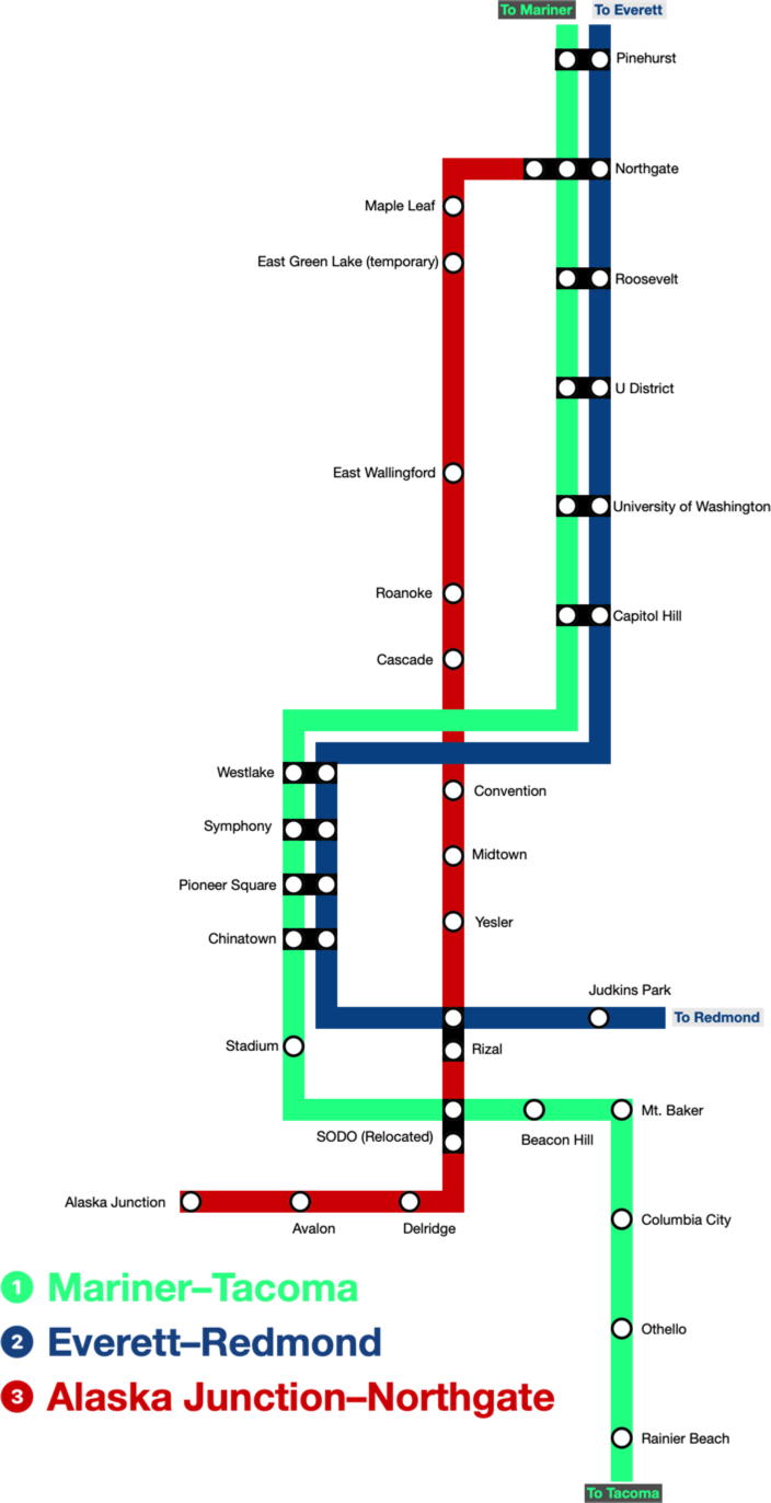
The following is an abstract system map (not to scale) of the rail system in Seattle described in this proposal.
Proposed Link system map in Seattle, when complete.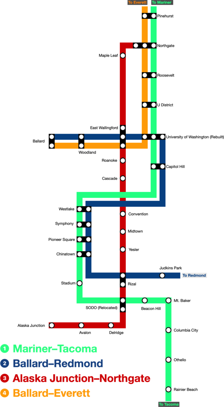
- There is no rail service to the Seattle Center, Smith Cove, or Interbay.
- Stops in the south (Denny) and west (South Lake Union) of South Lake Union are replaced by the Cascade stop on the eastern edge of the neighborhood.
- Service between Ballard and downtown is routed via the University of Washington, creating a frequent connection between Ballard and the university. This also connects Ballard to points north.
- The Maple Leaf, North Green Lake, Wallingford, Eastlake, North Capitol Hill, Convention Center, Pike-Pine, Yesler Terrace, Japantown, and North Beacon Hill neighborhoods gain rail service.
New and Repurposed Infrastructure
The majority of the project scope involves repurposing the current Interstate 5, between Northeast Northgate Way and the Spokane Street Viaduct into an exclusive transit corridor. Owing to its present use as an interstate highway, the right of way is already entirely grade separated. It is also substantially wider than the two tracks required for rail service, allowing platforms and stations to be constructed entirely within its footprint with minimal, if any, additional land acquisition. To minimize costs, the existing elevated structures and roadbed could be used as much as possible, in the manner of the 2 Line’s repurposing of the Interstate 90 express lanes. For stations, particularly transfer stations where new track must be within a reasonable horizontal distance of existing track to allow transfers, it may be necessary to selectively demolish sections of the highway and rebuild them to reach the required heights. In either case, the wide right of way and separation from local roads should minimize the extent to which construction impacts existing transit, homes, and businesses.
The Southwest Corridor in Boston illustrates a desirable endpoint of repurposing Interstate 5, albeit one going beyond strictly the scope of ST3. The cleared right of way for an abruptly cancelled interstate highway now houses subway service, commuter rail, high-speed electrified Amtrak service, a linear park, and sports fields. I-5 is even wider than the canceled highway that would have run in the Southwest Corridor; there may even be opportunities for new transit-oriented residential development where Interstate 5 once stood.
Southwest Corridor near Ruggles Station in Boston. “File:SouthwestCorridorParkRuggles.JPG” by Grk1011 is licensed under CC BY-SA 3.0.
The proposal also entails:
- Relocating SODO Station to the Beacon Hill portal, as part of a transfer station also serving the new 3 Line.
- Altering the planned elevated guideway in SODO to parallel the Spokane Street Viaduct for its full length, meeting the I-5 right of way at the relocated SODO station, rather than turning north onto the SODO Busway and connecting to the existing 1 Line.
- Adding side platforms to the current 2 Line track at a point west of Dr. Jose Rizal Park, as part of a transfer station also serving the new 3 Line.
- Constructing 3 Line rail yards and maintenance facilities in the footprint of the current Mercer Street and State Route 520 interchanges.
- Construction of a light rail guideway between the current University of Washington Station and Ballard. This would be a tunnel roughly following the course of King County Metro’s 44 bus, or a combination of a tunnel and elevated viaduct, given the elevation changes between the endpoints.
- Rebuilding University of Washington Station as a multi-way transfer point between three light rail lines.
The Lines
This proposal encompasses four transit lines that partly operate in Seattle. An additional light rail line between Issaquah and South Kirkland, that is described in the ST3 plan, is not affected by this proposal.
The 1 Line will run between Mariner and Tacoma using existing light rail technology on a combination of previously built track, and track planned as part of the Everett and Tacoma extensions.
The 2 Line will run between Ballard and Redmond using existing light rail technology. Until the guideway between Ballard and University of Washington opens and the 4 Line launches, it will have an interim routing between Redmond and the northernmost completed station of the Everett extension. Its final infrastructure will be a combination of existing track between Redmond and University of Washington, and proposed track between University of Washington and Ballard.
The 3 Line will run between Alaska Junction and Northgate, and consist of entirely new transit infrastructure. It will not intersect any light rail lines at the track level, allowing any type of vehicles and guideway to be used. This, in combination with its total grade separation would allow automated service and higher-capacity heavy rail vehicles if desired.
The 4 Line will run between Ballard and Everett using existing light rail technology. Between Ballard and University of Washington, it will share the same proposed pathway used by the 2 Line. Between University of Washington and Everett it will use the existing and planned light rail tracks used by the 1 Line, sharing them with it until Mariner Station.
The Stations
These stations are either new or modified under this proposal:
- ❶❸❹Northgate: The current light rail portion of this station will be unchanged. A new platform will be constructed at the mezzanine level, perpendicular to the current tracks. It will serve as the northern terminus of the 3 Line as it curves from its I-5 alignment to meet the existing station.
- ❸Maple Leaf: This station will lid a portion of the current interstate trench immediately south of the existing Northeast 80th Street bridge.
- ❸East Green Lake (temporary): This will be an elevated station with access from the existing Green Lake Park-and-Ride lot. It will serve as a temporary replacement for Roosevelt Station while the 1 and interim 2 Lines are bifurcated by the reconstruction of University of Washington Station (see System Disruption). Once that is complete, it will be decommissioned and its site redeveloped, as it is too far from Roosevelt Station to allow for a short transfer, but close enough to duplicate most of its walkshed.
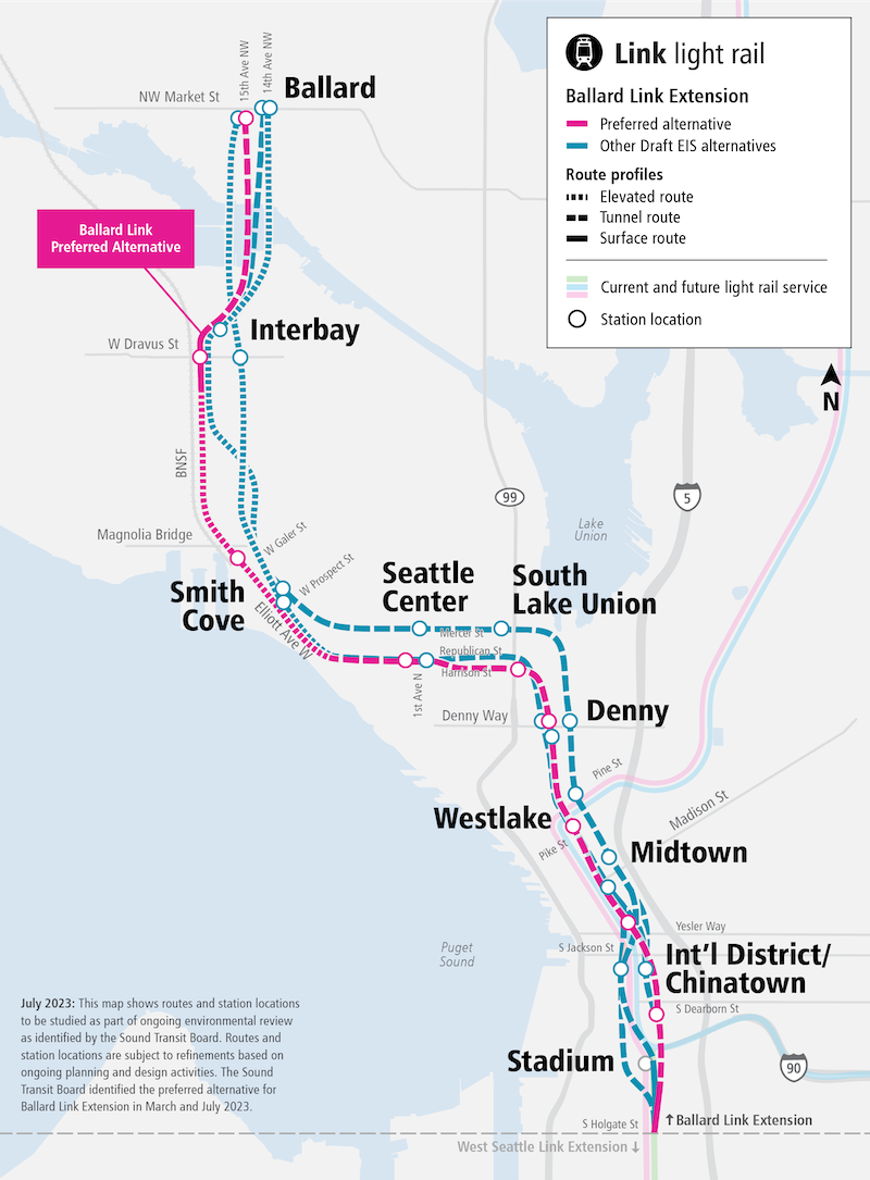
- ❷❹Ballard: This proposal does not strictly prescribe where Ballard Station would be, or whether it would be underground or elevated. This depends on whether an entirely tunneled, or tunnel and viaduct alignment is chosen from Woodland Station. Unlike the Ballard Link Extension’s preferred alternative, by approaching Ballard from the east rather than the south, it is more feasible to serve the center of Ballard rather than its outskirts on 15th Avenue Northwest.
- ❷❹Woodland: This station will be underground in the vicinity of North 46th Street and Aurora Avenue North, allowing a connection with the RapidRide E Line.
- ❷❸❹East Wallingford: This station will be built in the current I-5 trench north of Northeast 45th Street and have platforms at two levels. One level would be oriented north-south for the 3 Line, the other east-west for the 2 and 4 Lines. The vertical ordering depends on the depth of the tunnel from University of Washington Station.
- ❶❷❹University of Washington: This station would be entirely rebuilt to support a multiway intersection of light rail lines. 1 Line trains go straight through the station; Ballard-bound 2 Line trains turn from north to west; Redmond-bound 2 Line trains turn from east to south; Ballard-bound 4 line trains turn from south to west; Everett-bound 4 Line trains turn from east to north. This could be done with multiple platforms at a single level connected by a mezzanine, or platforms at multiple levels. The presence of large parking lots south of the present University of Washington Station would allow staging and excavation more easily than siting a transfer point at U District Station. Rebuilding would completely close it, temporarily bifurcating the current 1 Line and the interim 2 Line.
- ❸Roanoke: This station would lid a portion of the current I-5 trench south of East Roanoke Street.
- ❸Cascade: This station would be slightly elevated from the street level, accessible from Eastlake Avenue East between King County Metro’s bus layover area and operator restrooms.
- ❸Convention: This station would lid the trapezoidal area between Pine Street, Pike Street, Boren Avenue, and the Sound Transit-owned vacant parcel near the Paramount Theater.
- ❸Midtown: This station would lid the trench bordered by Spring Street, 7th Avenue, Madison Street, and 6th Avenue. It would allow a transfer to the RapidRide G Line.
- ❸Yesler: This station would lid a portion of the trench south of Yesler Way.
- ❷❸Rizal: This would be an elevated station, in the vicinity of where the current 2 Line guideway crosses Interstate 5, near Dr. Jose Rizal Park. Side platforms would be added to the 2 Line tracks, with access to perpendicular 3 Line tracks below. Access to the site is currently difficult, as it is in the middle of a highway interchange and of varying elevation, with no current roads providing pedestrian access. The closure of I-5, however, would remove the tangle of ramps that impede access, though I-90 would continue to limit it from the south. While the existing walkshed is poor, the land opened up by ramp removal would allow for nearby transit oriented development. Regardless of organic ridership from the station area, it must be built as a transfer point, as it is the only connection between the 2 and 3 Lines south of the ship canal.
- ❶❸SODO: This station would be elevated, with its lower level at the opening of the 1 Line’s Beacon Hill Portal, north of the Old Rainier Brewery. Side platforms would be added to the current guideway just before the tunnel. Above this, 3 Line tracks would run perpendicularly. Sound Transit owns a parcel to the south of the site, which could be used for construction staging and access. The existing SODO station would be closed. This would be the only transfer point between the 1 and 3 Lines south of the ship canal.
- ❸Delridge, ❸Avalon and ❸Alaska Junction: These will be constructed according to the existing West Seattle Link Extension plan, except they might not necessarily use light rail.
System Disruption
Construction of the 3 Line would disrupt light rail service minimally. The existing dedicated right of way, and that the new guideway between SODO and West Seattle doesn’t interact with the existing light rail system, limits impact to proposed transfer stations. The effect on Northgate station should be minimal, as the 3 Line portion of the station would largely be a new structure, connected only to the existing station’s mezzanine. Adding side platforms to existing guideway, which is how the Rizal and SODO stations will be built, could be managed similarly to the current construction of Pinehurst Station. This would mean single tracking when work is actively occurring. The construction of East Wallingford Station should include building the light rail platform for the 2 and 4 Lines to avoid disruption later.
Proposed Link system map in Seattle, before the University of Washington to Ballard guideway construction.
The construction of the University of Washington to Ballard guideway, used for the 2 Line and 4 Line, would disrupt service severely, but be manageable with the 3 Line in place. Rebuilding University of Washington Station to support a three-way transfer would necessitate a complete shut down. This would sever the 1 Line and interim 2 Line at University of Washington Station. 1 Line trains would run between Capitol Hill and Tacoma and between Mariner and U District. Interim 2 Line trains would run between Capitol Hill and Redmond and between Everett and U District.
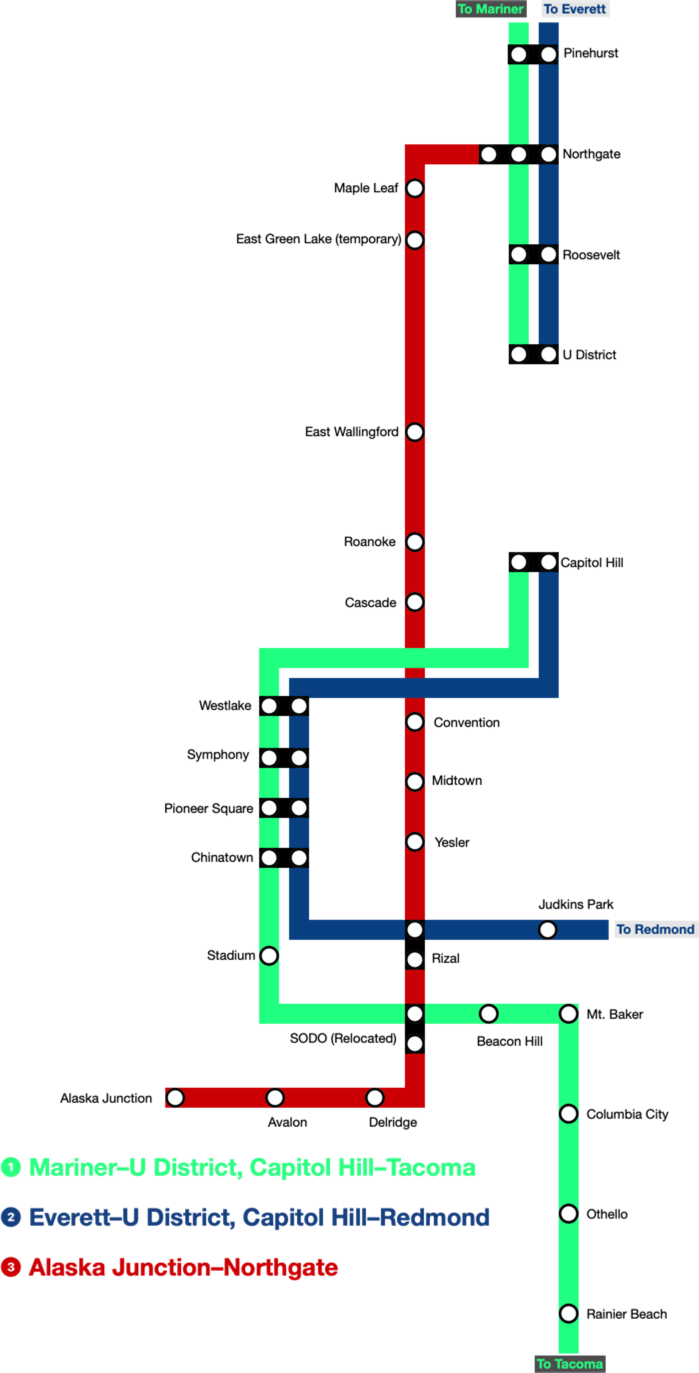
Proposed Link system map in Seattle, during University of Washington to Ballard guideway construction.
The presence of the 3 Line mitigates this. For riders originating at, or north of, Northgate, the 3 Line would get them downtown, albeit a few streets away from their original destinations. For destinations further south, or to reach the exact 1 or 2 Line stations used before, transfers to those lines could be made at SODO or Rizal. The reverse direction is the same.
Riders using Roosevelt Station are unaffected when going north. Going south, the temporary station at East Green Lake is approximately a quarter mile from Roosevelt. For southbound trips from U District Station, East Wallingford Station is a half mile from it, with frequent bus service connecting the two. Those in the vicinity of University of Washington Station itself will experience the worst disruption. Travel by rail both north and south will require using another station, and the nearest options for bidirectional travel, East Wallingford and Roanoke stations, are both about 1.5 miles away. A frequency boost to existing bus service between University of Washington Station, U District Station, and East Wallingford Station would serve as a natural shuttle.
Impacts on Roads
This proposal would alter driving patterns in greater Seattle. Interstate 405 would be redesignated Interstate 5, with the expectation that most traffic that once traveled through Seattle without exiting would use it. Two spur routes would exist for access to Seattle. The portion of what was once Interstate 5 between the present I-405 and Northeast Northgate Way would be designated Interstate 105; the portion between the present I-405 and the Spokane Street Viaduct would be Interstate 305. On I-305, connections to the Spokane Street Viaduct and Columbian Way would be maintained at the northern terminus.
State Route 520 would end at East Roanoke Street in the westbound direction, and begin at Lake Washington Boulevard in the eastbound direction. This would leave the eastbound lanes of the Portage Bay Viaduct entirely unused. Interstate 90 would continue to terminate in SODO, with no changes aside from the elimination of ramps connecting to the repurposed section of I-5.
Divesting of this infrastructure at this time would be a boon for the Washington State Department of Transportation. The agency is amidst work to replace the Portage Bay Viaduct, which could be reduced in scope if only a portion of it is retained. It could also downsize its ongoing Revive I-5 project. Sound Transit could pick up whatever contracts have already been awarded for work on the portion of the highway that will be repurposed for rail. It would collaborate with the contractors to change the scope of work to preparing for rail installation.
The changes to road infrastructure would ultimately disentangle Seattle-bound Interstate 5 traffic from vehicles passing through it. It would instead intermingle through traffic with vehicles using the current Interstate 405 to access Seattle’s eastern suburbs. While this increase in vehicle volume may be unpalatable to people in those suburbs, they stand to lose the most if the current preferred alternative is built instead of this proposal. Moreover, the goals of constructing a regional rail system, and Bus Rapid Transit on I-405 itself, include having fewer cars on the road. If the system works, losing the vehicular capacity of 10 miles of I-5 should not be as impactful as it initially appears.
Summary
The initial Sound Transit 3 project plan was notably ambitious and competent. It proposed a second downtown tunnel that was truly a regional asset, because it put transfer points in Seattle that enabled travel throughout the Sound Transit service area. As concerns around its cost and disruption have emerged, regional connectivity has been chosen as the currency to exchange in favor of reduced risk. The planned rail system would get people into and out of downtown Seattle, but has deficiencies that would hinder the ability of riders to use Seattle as a connection point for journeys elsewhere in the region. Canceling the second tunnel altogether would worsen the system in a different way, by saddling future riders with a single point of failure that makes them unable to trust their public transit. This will yield a system acceptable for commutes and occasional congregation, but not for living a life in which public transit can be one’s primary way of getting around.
Rather than squandering a generational opportunity to build the kind of transit system that people adopt as their transportation mode of choice, this proposal suggests that a different tradeoff could be made. Reusing Interstate 5’s existing grade-separated right of way and canal crossing, rather than creating new ones, eliminates a costly and risky element of the planned project. It also moves complex station rebuilds out of the core of Seattle, where they can be accomplished with manageable disruption, while still providing a set of transfer points that enable regional connectivity, and completing most all the objectives of ST3. Instead of hurting future generations of potential transit riders, it asks today’s motorists to forfeit a small piece of infrastructure that was never a good fit for a city like Seattle anyway.
Interstate 5 slashed a wound through the core of Seattle. It was so immediately recognized as a deleterious choice, that residents rejected subsequent attempts at highway construction. It subjects numerous neighborhoods to continuous din, and snarls the local road network for everyone around its ramps. It is so clearly recognized as an eyesore that is already an effort to lid it, but the situation that Sound Transit finds itself in right now can be reframed as an opportunity to heal the wound rather than covering it. Converting I-5 to an asset within a public transit system enthusiastically approved by voters begins a healing process, while rescuing the region’s public transit future.